Algonquin Island
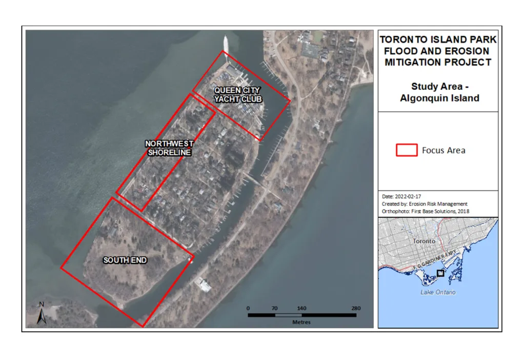
Algonquin Island includes residential homes, a local school, and a naturalized area with several ecologically significant plant communities. Three focus areas have been identified within the Algonquin Island study area based on flood risk to existing infrastructure. The focus areas are the Northwest Shoreline, South End, and Queen City Yacht Club.
Algonquin Island Study Area
Select a focus area to learn more about the preferred concept solution.
Overview of Algonquin Island Flood Solutions
Separate sets of concept designs were developed for each focus area in Algonquin Island to ensure that flood solutions are suitable to various site conditions and needs across the study area.
The preferred solution for the South End is a vegetated inland berm. The preferred solution for the Northwest Shoreline is an impermeable berm and nearshore habitat. The preferred solution for Queen City Yacht Club is land raising and a raised walkway. More information about these solutions can be found on each focus area page.
The map shows how the preferred solutions for each focus area will work together to protect the Algonquin Island shoreline in the event of another flood. With these solutions in place, the key focus areas will be protected from flooding impacts. A portion of the South End, where there is no existing infrastructure, will be left unprotected and allowed to naturally flood.
Detailed Environmental Analysis
The categories below summarize anticipated impacts of the proposed solutions for flood mitigation at Algonquin Island. Interested in learning more? Click here to view the full Detailed Environmental Analysis for Algonquin Island.
Physical Environment
- The nearshore habitat design along the Northwest Shoreline will help retain beach sediment, benefit water quality, reinstate natural geomorphic processes, and shelter docked boats at QCYC
- The installation of impermeable flood barriers around the shoreline of the study area will impede surface drainage to the lake. The addition of sump pumps or other considerations will need to be reviewed during detailed design to mitigate this impact
- Noise and vibration impacts are expected during construction, but these will be temporary
- Despite efforts to optimize the layout of the inland berm in the South End, its construction will disrupt the Environmentally Significant Area that is located here
Biological Environment
- The nearshore habitat design for the Northwest Shoreline will benefit fish and wildlife and encourage the establishment of important coastal vegetation communities
- Despite efforts to optimize the layout of the inland berm in the South End, its installation will disrupt the Environmentally Significant Area and other vegetation communities that are located here
- Installation of the shoreline berm in the South End may impact hydrology of the Provincially Significant Wetland located in this area. Review will be required during detailed design to mitigate impacts
Cultural Environment
- Overall impacts are expected to be positive
- Recreational opportunities, aesthetic features, and access to the shoreline will be improved and enhance park user experience
Socioeconomic Environment
- Flood protection will directly benefit Algonquin Island residents and QCYC members as well as maintain access to recreational and operational buildings during a flood event
- The proposed designs for the Northwest Shoreline and South End will promote recreational use and enhance visitor experience
- Increased recreational use of this area may impact residents and place additional pressure on existing infrastructure
Engineering/Technical Environment
- Overall impacts are expected to be positive
- Erosion and flood risks will be reduced
- Existing shoreline infrastructure will be improved
- Natural sediment deposition will be promoted


