Scarborough Waterfront Project
Brimley Road South Multi-Use Trail Detailed Design
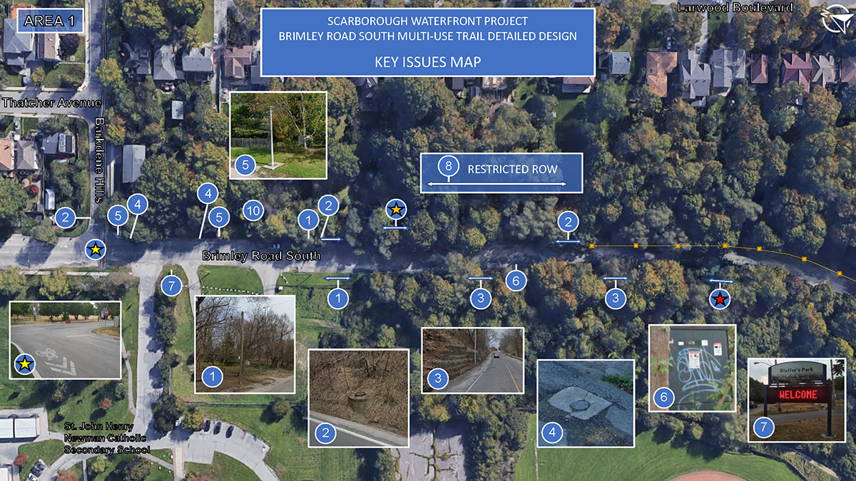
Key Issues Map Legend - Area #1
1. Utility poles and / or guy anchors will require relocation as a result of the multi-use trail.
2. Maintenance holes and catch basins will require potential location / adjustments. Underground Toronto Water infrastructure present on east side.
3. Steep slopes. Embankments requiring significant slope cuts, if modified.
4. Monitoring well.
5. Landfill monitoring infrastructure.
6. Toronto Hydro pad mounted transformer.
7. Bluffer’s Park sign.
8. Restricted right-of-way (ROW) of existing roadway constrains trail through north section.
10. Existing pathway to be decommissioned and re-aligned along the east side of Brimley Road South to reduce steep grade.
* (yellow) Intersection Improvement: All-way stop, pedestrian crossings.
* (orange) Potential Former Landfill (full extent unknown): Limit excavations and minimize slope cuts to mitigate risks and impacts associated with contaminated soils.
* (red) Former Landfill: Limit excavations and minimize slope cuts to mitigate risks and impacts associated with contaminated soils and slope destabilization through-out site.
.
Scarborough Waterfront Project
Brimley Road South Multi-Use Trail Detailed Design
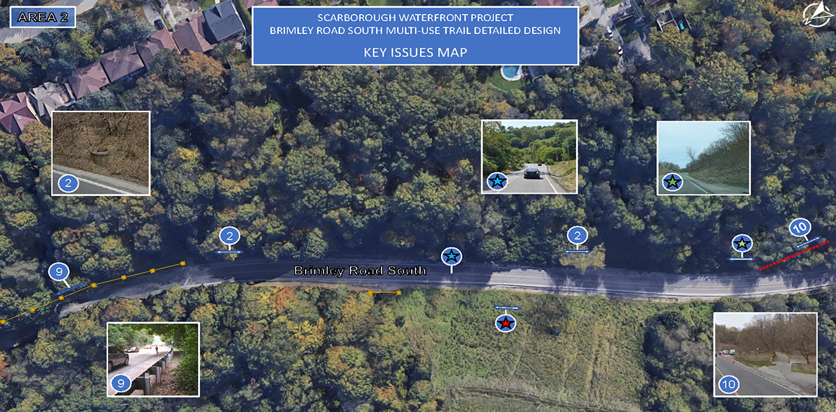
Key Issues Map Legend - Area #2
2. Maintenance holes and catch basins will require potential location / adjustments. Underground Toronto Water infrastructure present on east side.
9. Guardrail removal / replacement.
10. Existing pathway to be decommissioned and re-aligned along the east side of Brimley Road South to reduce steep grade.
* (blue) Steep road grades up to 17% along Brimley Road South.
* (green) Limiting slope cuts into embankments. Required implementation of slope stabilization.
* (red) Former Landfill: Limit excavations and minimize slope cuts to mitigate risks and impacts associated with contaminated soils and slope destabilization through-out site.
.
Scarborough Waterfront Project
Brimley Road South Multi-Use Trail Detailed Design
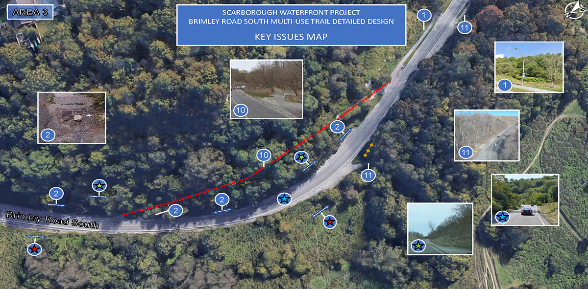
Key Issues Map Legend - Area #3
1. Streetlighting will require relocation as a result of the multi-use trail.
2. Maintenance holes and catch basins will require potential relocation / adjustments. Underground Toronto Water infrastructure present on east side.
10. Existing pathway to be decommissioned and re-aligned along the east side of Brimley Road South to reduce steep grade.
11. Existing truck escape lane.
* (blue) Steep road grades up to 17% along Brimley Road South.
* (green) Limiting slope cuts into embankments. Required implementation of slope stabilization.
* (red) Former Landfill: Limit excavations and minimize slope cuts to mitigate risks and impacts associated with contaminated soils and slope destabilization through-out site.
.
Scarborough Waterfront Project
Brimley Road South Multi-Use Trail Detailed Design
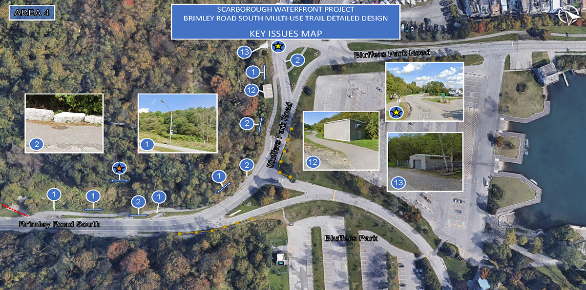
Key Issues Map Legend - Area #4
1. Streetlighting will require relocation as a result of the multi-use-trail.
2. Maintenance holes and catch basins will require potential relocation / adjustments. Underground Toronto Water infrastructure present on east side.
12. Hydro maintenance facility.
13. Bluffer's Park maintenance facility.
* (yellow) Intersection Improvement: All-way stop with combined cross-ride for cyclists and pedestrians.
* (orange) Potential Former Landfill (full extent unknown): Limited excavations and minimize slope cuts to mitigate risks and impacts associated with contaminated soils.

